Publications

15 publications, 12 as first or co-first author and 6 introducing public datasets or benchmarks. Also on Google Scholar.

2027

WACV 2027 accepted

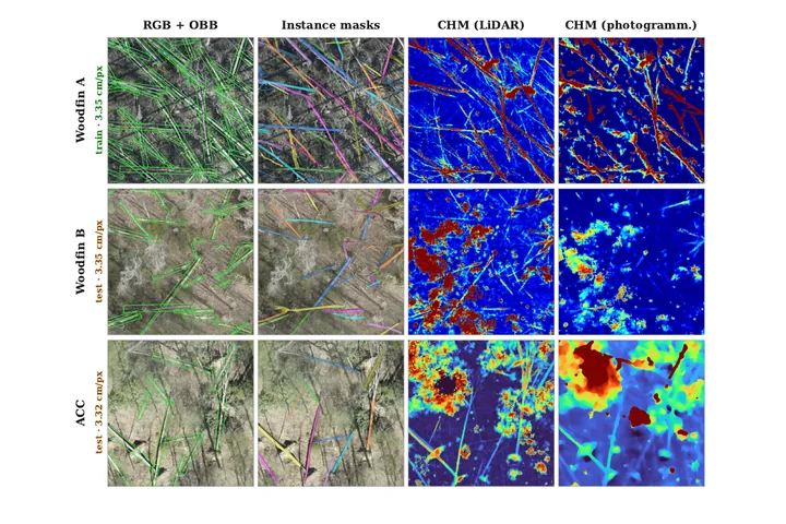
CWDBench: A Benchmark for Instance-Level Characterization of Coarse Woody Debris in Aerial Imagery

Oishee Bintey Hoque, Theresa Chen, K. C. Cushman, Philipe Ambrozio Dias

IEEE/CVF Winter Conference on Applications of Computer Vision (WACV), Datasets Track First public benchmark for fallen-log detection in centimeter-resolution UAV orthomosaics: 10,399 verified instances with oriented boxes and masks, paired LiDAR and photogrammetric height models, and a centerline-based metric for elongated objects.
2026

OASIS @ SIGSPATIAL 2026

ARFA: An Agentic System for Real-Time Riverine Flood Response

Youssef Hussein, JangHyeon Lee, Oishee Bintey Hoque, Dalton Lunga

1st ACM SIGSPATIAL Student Challenge on Open Agents with Spatial Intelligence for Social Good (OASIS 2026) Challenge finalist. A hybrid agentic system that pairs LLM agents for location, structure and reasoning with deterministic geospatial tools for flood assessment, facility discovery and evacuation routing.

EarthVision @ CVPR 2026

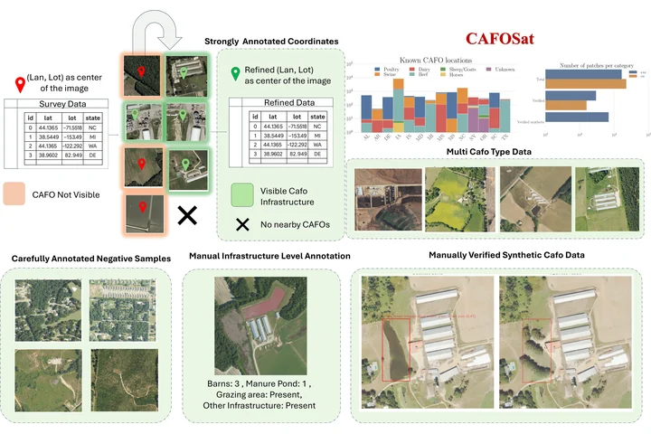
CAFOSat: A Strongly Annotated Dataset for Infrastructure-Aware CAFO Mapping Using High-Resolution Imagery

Oishee Bintey Hoque*, Nibir Chandra Mandal*, Mandy L. Wilson, Samarth Swarup, Madhav Marathe, Abhijin Adiga *equal contribution

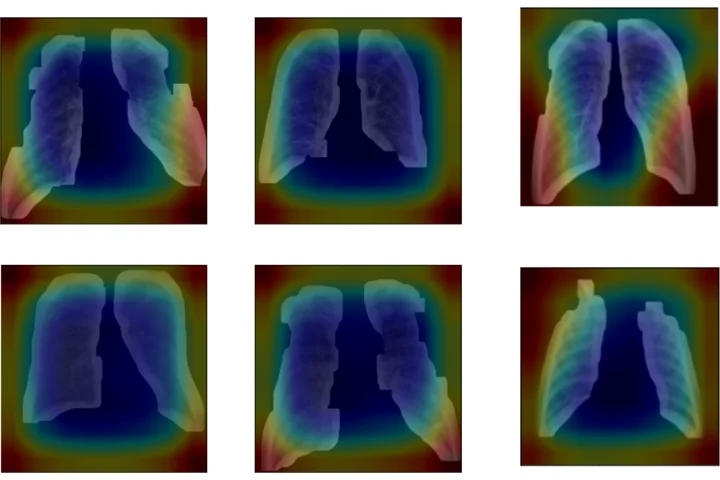
EarthVision Workshop, IEEE/CVF Conference on Computer Vision and Pattern Recognition (CVPR) A semi-automated annotation pipeline that uses classifier Grad-CAM heatmaps to re-localize imprecise public CAFO records and refine them into facility boxes and infrastructure-level labels, with curated hard negatives and validated synthetic imagery from GroundingDINO-guided Stable Diffusion inpainting to benchmark robustness under distribution shift.

WACV 2026

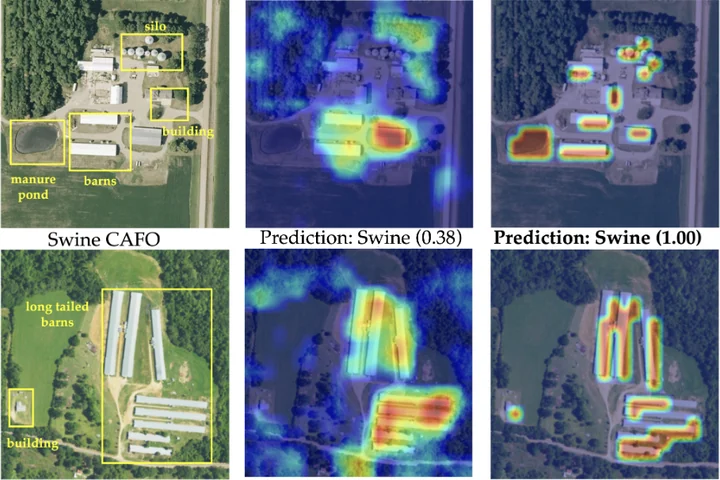
PRISM-CAFO: Prior-Conditioned Remote-Sensing Infrastructure Segmentation and Mapping for CAFOs

Oishee Bintey Hoque*, Nibir Chandra Mandal*, Kyle Luong, Mandy L. Wilson, Samarth Swarup, Madhav Marathe, Abhijin Adiga *equal contribution

IEEE/CVF Winter Conference on Applications of Computer Vision (WACV) Infrastructure-first, explainable CAFO mapping: YOLO detects barns, lagoons and feedlots, SAM turns them into geometry-filtered masks, and structural descriptors fused with deep visual features classify the facility type and tie each decision to visible infrastructure.

2025

NeurIPS 2025

IRRISIGHT: A Large-Scale Multimodal Dataset and Scalable Pipeline to Address Irrigation and Water Management in Agriculture

Nibir Chandra Mandal*, Oishee Bintey Hoque*, Mandy L. Wilson, Samarth Swarup, Sayjro K. Nouwakpo, Abhijin Adiga, Madhav Marathe *equal contribution

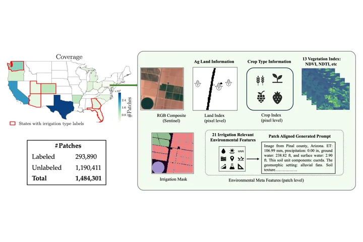
Advances in Neural Information Processing Systems (NeurIPS) A scalable pipeline that aligns raster, vector and point data (soil, hydrology, crops, land use, climate) on a common 10 m grid and turns tabular attributes into domain-informed text prompts: 1.4M pixel-aligned image–text patches across 20 states for benchmarking vision and vision–language models.

IJCAI 2025

IGraSS: Learning to Identify Infrastructure Networks from Satellite Imagery by Iterative Graph-Constrained Semantic Segmentation

Oishee Bintey Hoque, Abhijin Adiga, Aniruddha Adiga, Siddharth Chaudhary, Madhav V. Marathe, S. S. Ravi, Kirti Rajagopalan, Amanda Wilson, Samarth Swarup

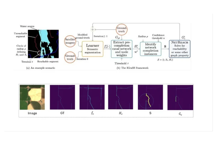
International Joint Conference on Artificial Intelligence (IJCAI) An iterative framework that couples semantic segmentation (RGB, NDWI and elevation inputs) with graph-based reachability constraints that repair incomplete canal ground truth, then retrains on the refined labels; a different graph constraint carries it over to road networks. Also proposes r-neighborhood metrics (rIoU, rPrecision, rRecall, rF1) that tolerate the small offsets of single-pixel annotations of thin structures.

IJCAI 2025

Knowledge-Informed Deep Learning for Irrigation Type Mapping from Remote Sensing

Oishee Bintey Hoque*, Nibir Chandra Mandal*, Abhijin Adiga, Samarth Swarup, Sayjro K. Nouwakpo, Amanda Wilson, Madhav Marathe *equal contribution

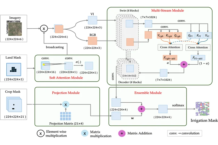
International Joint Conference on Artificial Intelligence (IJCAI) A Swin-Transformer segmentation model that injects agronomic knowledge: a projection matrix encoding crop-to-irrigation probabilities, a spatial attention map separating farmland from non-agricultural land, bi-directional cross-attention between image and crop modalities, a weighted ensemble, and two-phase transfer learning across states.

KDD 2025

IrrMap: A Large-Scale Comprehensive Dataset for Irrigation Method Mapping

Nibir Chandra Mandal*, Oishee Bintey Hoque*, Abhijin Adiga, Samarth Swarup, Mandy L. Wilson, Lu Feng, Yangfeng Ji, Miaomiao Zhang, Geoffrey Fox, Madhav Marathe *equal contribution

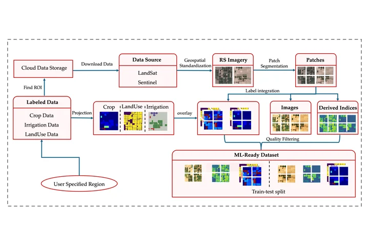
ACM SIGKDD Conference on Knowledge Discovery and Data Mining (KDD) An extensible, ML-ready pipeline that fuses multi-resolution Landsat and Sentinel imagery with crop type, land use and vegetation indices into 1.1M geospatially aligned 224×224 patches, with curated train–test splits, dataloaders and benchmark segmentation models.

2024

V4A @ CVPR 2024

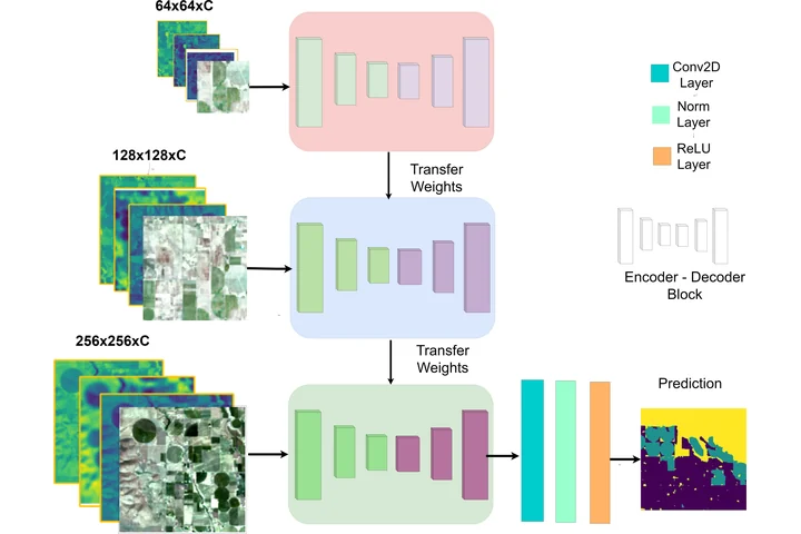
IrrNet: Advancing Irrigation Mapping with Incremental Patch Size Training on Remote Sensing Imagery

Oishee Bintey Hoque, Samarth Swarup, Abhijin Adiga, Sayjro Kossi Nouwakpo, Madhav Marathe

Vision for Agriculture Workshop, IEEE/CVF Conference on Computer Vision and Pattern Recognition (CVPR) An incremental patch-size training scheme in which models learn fine field-level detail on small patches before broader landscape context on progressively larger ones, for irrigation mapping from Landsat 5 and 7 imagery.

2023

2021

2020

2018