
Oishee Bintey Hoque
PhD Candidate in CS @ UVA · Applied Scientist Intern @ Amazon Science · Former Research Intern @ ORNL
I'm a PhD candidate in Computer Science at the University of Virginia and a recipient of the UVA SEAS Endowed Fellowship 2025, advised by Dr. Madhav Marathe at the Biocomplexity Institute, University of Virginia. I build multimodal and vision–language models for detection, segmentation and scene understanding.
I'm currently an Applied Scientist Intern at Amazon Science, building multimodal AI for retail smart glasses: real-time on-device vision, cloud foundation models, and the hands-free AR and voice workflows on top. Before joining Amazon I spent a summer as a Graduate Research Intern in the GeoAI group at Oak Ridge National Laboratory, and before the PhD I worked as a software engineer at Enosis Solutions.
My PhD research is in computer vision for Earth observation: knowledge-guided and multimodal learning, vision–language models, and foundation-model adaptation for remote sensing, applied to agricultural and environmental monitoring. My PhD work runs along three threads:
Knowledge-guided Multimodal Learning & Vision
Segmentation and detection architectures that take domain structure as input instead of relearning it: crop and land-use priors through cross-attention, graph constraints on canal networks, and geometric priors on infrastructure.
- KIIM IJCAI ’25
- IGraSS IJCAI ’25
- PRISM-CAFO WACV ’26
ML-ready datasets and benchmarks
Scalable pipelines that turn raw satellite and UAV archives into annotated detection and segmentation benchmarks: multimodal inputs, metadata, held-out sites and task-specific metrics.
Foundation models and agentic geospatial systems
Adapting SAM-, DINO- and Swin-based models and vision–language models to remote-sensing detection and segmentation, and composing LLM agents with deterministic geospatial tools for operational decision support.
- PRISM-CAFO WACV ’26
- ARFA OASIS @ SIGSPATIAL ’26
- CWDBench WACV ’27
- Core skills
- Multimodal fusion Semantic and instance segmentation Object detection Geospatial AI Foundation-model adaptation Vision–language models Agentic AI ML-ready dataset pipelines
Graduating in early 2027 and looking for applied and research scientist roles. Please feel free to reach out!
News
- Oct 2026 First-author paper accepted at WACV 2027 Work from my internship at Oak Ridge National Laboratory.
- Sep 2026 Google DeepMind travel grant to our team For the ARFA team at the OASIS 2026 challenge, ACM SIGSPATIAL, Riverside, CA.
- Sep 2026 Our team is a finalist in the ACM SIGSPATIAL OASIS 2026 student challenge ARFA, an agentic flood-response assistant.
- Sep 2026 Joined Amazon Science as an Applied Scientist Intern Working with the Amazon GRAISE team in Seattle.
- May 2026 Started a research internship at Oak Ridge National Laboratory GeoAI group, GRO program.
- Oct 2025 UVA SEAS Endowed Fellowship $12,000 award given to 20–25 doctoral students across the School of Engineering, 2025–26.
See more newsShow fewer
| Jun 2026 | Presented at CVPR 2026 CAFOSat, EarthVision workshop, Denver. |
|---|---|
| Mar 2026 | Paper accepted at EarthVision, CVPR 2026 CAFOSat. |
| Feb 2026 | Travel grant, HARVEST-VISION workshop at WACV 2026 AIVO travel grant. |
| Nov 2025 | Paper accepted at WACV 2026 PRISM-CAFO. |
| Sep 2025 | Paper accepted at NeurIPS 2025 IRRISIGHT. |
| Aug 2025 | Presented at IJCAI 2025 IGraSS and KIIM, oral and poster, Montréal. |
| Aug 2025 | Mentored two undergraduate researchers Biocomplexity Institute, summer 2025. |
| Jun 2025 | Paper accepted at KDD 2025 IrrMap. |
| Jun 2025 | Two papers accepted at IJCAI 2025 IGraSS and KIIM. |
| Jun 2024 | Presented at CVPR 2024 IrrNet, oral and poster at V4A; poster at WiCV. Seattle. |
| May 2024 | CVPR 2024 DEI travel grant and WiCV travel grant |
| Apr 2024 | Paper accepted at V4A, CVPR 2024 IrrNet, oral and poster. Extended abstract accepted at WiCV. |
| Apr 2024 | Doctoral Consortium, Tapia 2024 Accepted with a full travel grant; poster on irrigation canal mapping. |
| Jan 2024 | Social Chair, UVA CS Graduate Student Group Council |
| Jun 2023 | Started a research internship with USDA-ARS SCINet / AI-COE Graduate Student Internship Program. |
| Apr 2023 | USDA-ARS AI-COE / SCINet fellowship |
| Apr 2023 | Presented at the CCI Symposium 2023 Also attended the CRA-WP Grad Cohort for Women. |
| Jan 2023 | Paper published in Scientific Data (Nature) COVID-19 policy data annotation, co-first author. |
| Jan 2023 | 3rd place, AgAthon 2023 AgAID digital hackathon. |
| Jan 2022 | Space and Media Chair, UVA CS Graduate Student Group Council |
| Jan 2021 | Journal paper accepted at SN Computer Science COVID-19 detection from chest X-rays. |
| Dec 2020 | Presented at ICCIT 2020 and the MLCSA workshop, ACCV 2020 |
| Oct 2020 | Papers accepted at MLCSA, ACCV 2020 and at ICCIT 2020 BdSL36 and document deblurring. |
| Dec 2018 | Presented at ICIET 2018 Real-time Bangladeshi Sign Language detection. |
| Nov 2018 | ACM ICPC Dhaka Regionals and National Girls Programming Contest 2016–2018; 11th of 120 teams in 2018. |
Featured publications
WACV 2027 accepted
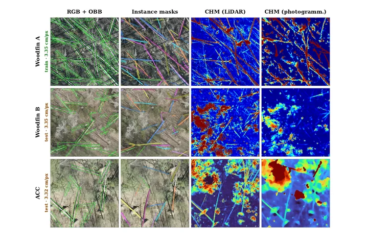
CWDBench: A Benchmark for Instance-Level Characterization of Coarse Woody Debris in Aerial Imagery
IEEE/CVF Winter Conference on Applications of Computer Vision (WACV), Datasets Track First public benchmark for fallen-log detection in centimeter-resolution UAV orthomosaics: 10,399 verified instances with oriented boxes and masks, paired LiDAR and photogrammetric height models, and a centerline-based metric for elongated objects.
OASIS @ SIGSPATIAL 2026
ARFA: An Agentic System for Real-Time Riverine Flood Response
1st ACM SIGSPATIAL Student Challenge on Open Agents with Spatial Intelligence for Social Good (OASIS 2026) Challenge finalist. A hybrid agentic system that pairs LLM agents for location, structure and reasoning with deterministic geospatial tools for flood assessment, facility discovery and evacuation routing.
EarthVision @ CVPR 2026
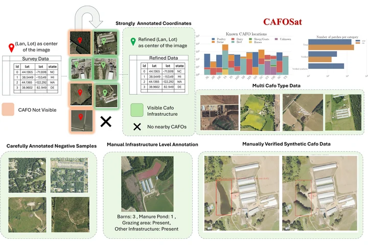
CAFOSat: A Strongly Annotated Dataset for Infrastructure-Aware CAFO Mapping Using High-Resolution Imagery
EarthVision Workshop, IEEE/CVF Conference on Computer Vision and Pattern Recognition (CVPR) A semi-automated annotation pipeline that uses classifier Grad-CAM heatmaps to re-localize imprecise public CAFO records and refine them into facility boxes and infrastructure-level labels, with curated hard negatives and validated synthetic imagery from GroundingDINO-guided Stable Diffusion inpainting to benchmark robustness under distribution shift.
WACV 2026
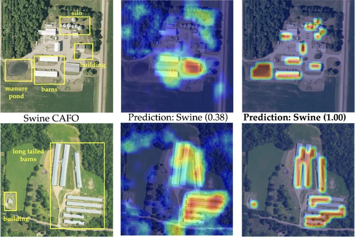
PRISM-CAFO: Prior-Conditioned Remote-Sensing Infrastructure Segmentation and Mapping for CAFOs
IEEE/CVF Winter Conference on Applications of Computer Vision (WACV) Infrastructure-first, explainable CAFO mapping: YOLO detects barns, lagoons and feedlots, SAM turns them into geometry-filtered masks, and structural descriptors fused with deep visual features classify the facility type and tie each decision to visible infrastructure.
NeurIPS 2025
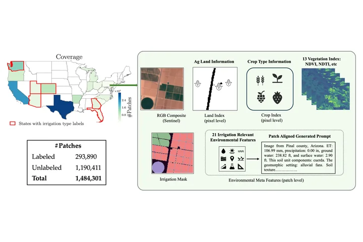
IRRISIGHT: A Large-Scale Multimodal Dataset and Scalable Pipeline to Address Irrigation and Water Management in Agriculture
Advances in Neural Information Processing Systems (NeurIPS) A scalable pipeline that aligns raster, vector and point data (soil, hydrology, crops, land use, climate) on a common 10 m grid and turns tabular attributes into domain-informed text prompts: 1.4M pixel-aligned image–text patches across 20 states for benchmarking vision and vision–language models.
IJCAI 2025
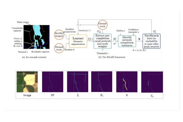
IGraSS: Learning to Identify Infrastructure Networks from Satellite Imagery by Iterative Graph-Constrained Semantic Segmentation
International Joint Conference on Artificial Intelligence (IJCAI) An iterative framework that couples semantic segmentation (RGB, NDWI and elevation inputs) with graph-based reachability constraints that repair incomplete canal ground truth, then retrains on the refined labels; a different graph constraint carries it over to road networks. Also proposes r-neighborhood metrics (rIoU, rPrecision, rRecall, rF1) that tolerate the small offsets of single-pixel annotations of thin structures.
IJCAI 2025
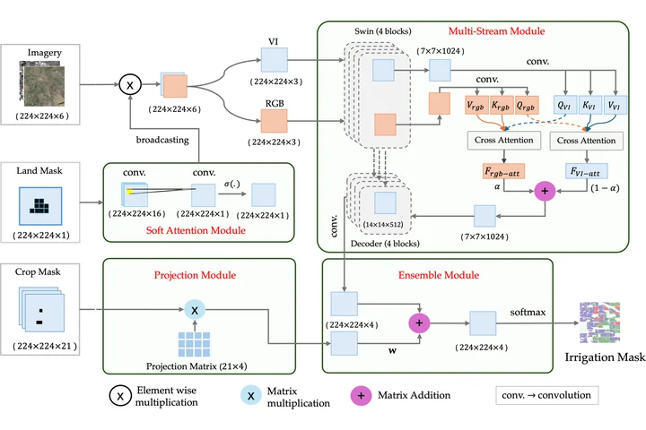
Knowledge-Informed Deep Learning for Irrigation Type Mapping from Remote Sensing
International Joint Conference on Artificial Intelligence (IJCAI) A Swin-Transformer segmentation model that injects agronomic knowledge: a projection matrix encoding crop-to-irrigation probabilities, a spatial attention map separating farmland from non-agricultural land, bi-directional cross-attention between image and crop modalities, a weighted ensemble, and two-phase transfer learning across states.
KDD 2025
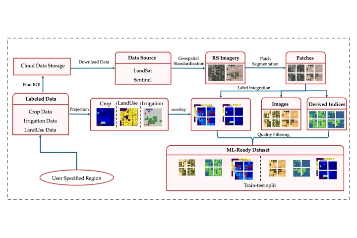
IrrMap: A Large-Scale Comprehensive Dataset for Irrigation Method Mapping
ACM SIGKDD Conference on Knowledge Discovery and Data Mining (KDD) An extensible, ML-ready pipeline that fuses multi-resolution Landsat and Sentinel imagery with crop type, land use and vegetation indices into 1.1M geospatially aligned 224×224 patches, with curated train–test splits, dataloaders and benchmark segmentation models.
V4A @ CVPR 2024
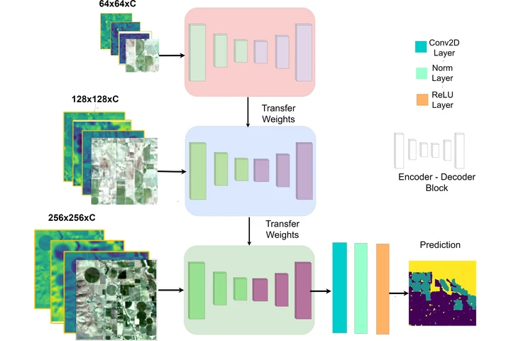
IrrNet: Advancing Irrigation Mapping with Incremental Patch Size Training on Remote Sensing Imagery
Vision for Agriculture Workshop, IEEE/CVF Conference on Computer Vision and Pattern Recognition (CVPR) An incremental patch-size training scheme in which models learn fine field-level detail on small patches before broader landscape context on progressively larger ones, for irrigation mapping from Landsat 5 and 7 imagery.
No featured publications match this filter.